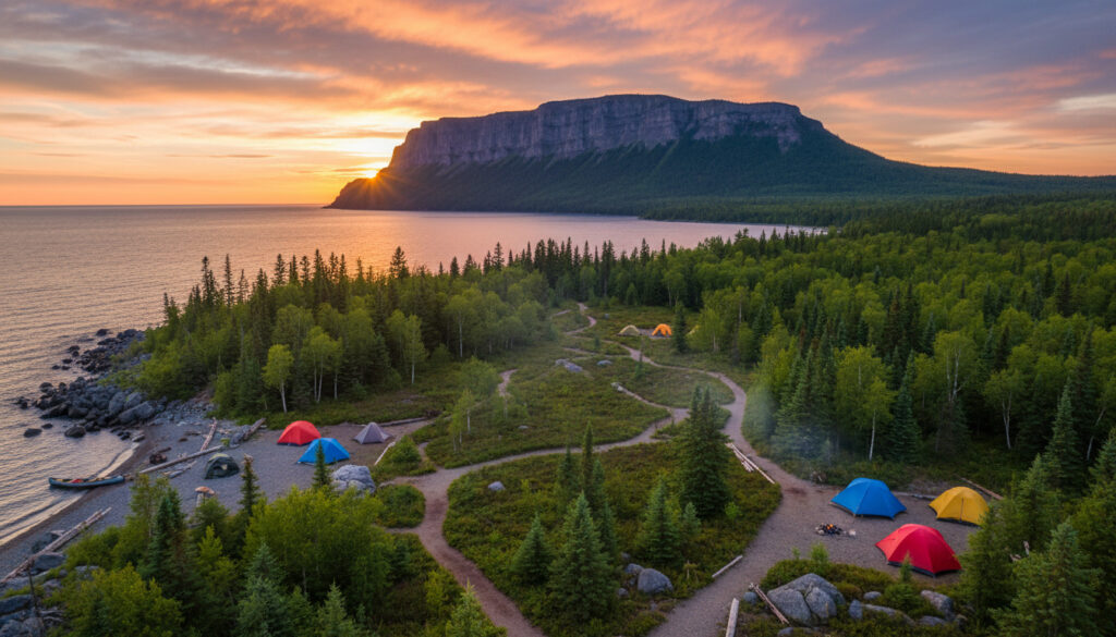
Sleeping Giant Provincial Park – Hiking Trails and Camping Guide
Sleeping Giant Provincial Park spreads across 244 square kilometres of the Sibley Peninsula, jutting into northern Lake Superior near Thunder Bay, Ontario. The park draws hikers and nature enthusiasts to its rugged quartzite cliffs, boreal forests, and the famous rock formation that resembles a reclining figure visible from the city.
With over 100 kilometres of trails traversing steep terrain and shoreline, the park centers on the Kabeyun Trail backbone and its most celebrated spur, the Top of the Giant. Ontario Parks manages the area, offering backcountry camping along isolated bays and access to the Gorge, which features a 950-foot vertical drop.
Where is Sleeping Giant Provincial Park Located?
The park occupies the Sibley Peninsula, extending approximately 40 kilometres into Lake Superior approximately 30 minutes east of Thunder Bay. The landscape comprises ancient quartzite tablelands, talus slopes, and boreal forest transitioning to rugged shoreline.
Key Park Facts
- The peninsula extends 40 kilometres into Lake Superior, creating diverse microclimates.
- The Sleeping Giant formation consists of ancient quartzite tableland created by geological uplift.
- Over 100 kilometres of trails range from easy boardwalks to strenuous 550-metre elevation gains.
- The Gorge features Ontario’s highest vertical drop at 950 feet.
- Local Ojibwe legend identifies the formation as the spirit Nanabozho turned to stone.
- Backcountry sites exist at Tee Harbour, Lehtinen’s Bay, and Sawyer Bay.
- Winter operations include 50 kilometres of groomed cross-country ski trails.
At-a-Glance Details
| Fact | Details |
|---|---|
| Total Area | 244 km² |
| Peninsula Length | 40 km |
| Trail Network | 100+ km |
| Primary Trail | Kabeyun Trail (37 km one-way) |
| Highest Elevation Gain | 550 m |
| Notable Drop | 950 ft (The Gorge) |
| Provincial Park Status | Designated (exact year unspecified) |
| Backcountry Sites | Tee Harbour, Lehtinen’s Bay, Sawyer Bay |
| Winter Trails | 50 km groomed cross-country skiing |
| Water Access | Marie Louise Lake Beach |
Is Sleeping Giant Provincial Park Open and What Are the Fees?
Current operating hours, seasonal closures, and fee structures for 2025 remain unspecified in publicly available documentation. Visitors must verify opening dates, camping reservations, and daily vehicle permits directly through the Ontario Parks reservation system or official channels before traveling.
Seasonal accessibility varies significantly. Conditions on the Sibley Peninsula shift from snow-covered winter ski routes to fully operational summer hiking infrastructure, though specific transition dates depend on annual weather patterns. Some secondary roads and trailheads may carry seasonal restrictions not reflected in general park literature.
Fees, 2025 operating hours, reservation requirements, and real-time accessibility details should be confirmed directly with Ontario Parks before finalizing travel plans. Backcountry camping requires advance permits subject to capacity limits.
What Are the Best Hiking Trails in Sleeping Giant Provincial Park?
The trail network radiates from the Kabeyun Trail, a 37-kilometre one-way route running the peninsula’s length from the North Kabeyun Trailhead (Thunder Bay Lookout) to the South Kabeyun Trailhead on Highway 587. This backbone connects to Lake Superior bays including Clavet, Hoorigan, and Sawyer, with side spurs accessing the formation’s major features.
Top of the Giant Trail
The park’s signature route extends 3.3 kilometres from the Kabeyun Trail as a spur, forming part of a challenging 22-kilometre round-trip from the South Kabeyun parking area. The path traverses six relatively flat kilometres along the lakeshore before ascending steeply with a 550-metre elevation gain. Experienced hikers report the journey requires six to eight hours, culminating at the “head” of the Giant formation with views into The Gorge.
The initial 6 km follow easy lakeshore terrain before the route becomes steep and demanding. Proper footwear and elevation-ready conditioning are essential for the 550-metre climb. Lake Superior weather changes rapidly; carry layers even on warm days.
Kabeyun Trail Spur Routes
Multiple trails branch from the Kabeyun backbone. The Talus Lake Trail stretches six kilometres one-way between Sleeping Giant and Thunder Mountain, offering seasonal wildlife viewing opportunities and combining with other routes for 18.6 to 20.5-kilometre loops. Northern Ontario Travel identifies this as excellent terrain for observant hikers seeking backcountry solitude.
The Sawyer Bay Trail covers 5.7 kilometres one-way through rolling hills to a Lake Superior bay, while the Thunder Cape Trail extends 1.2 kilometres off the Kabeyun to the Thunder Cape Bird Observatory, traversing notable talus slopes. For easier options, the Thunder Bay Bogs Nature Trail offers a 0.7-kilometre loop featuring Labrador Tea and boreal plant species, and Sawbill Lake Trail provides a 2-kilometre out-and-back suitable for shorter visits.
Mountain biking is permitted on select routes including the Thunder Bay Lookout Road (9 km, steep) and Marie Louise Drive (12 km). Trails like Shifting Lake (4.2 km) allow off-leash pets in designated sections. Bear awareness protocols apply throughout the park during all seasons.
For those considering home maintenance before extended travel, see our guide on Rheem Hot Water Tank – Warranty Coverage Guide.
Can You Camp or Stay in Cabins at Sleeping Giant Provincial Park?
The park maintains backcountry camping sites along the trail network, including locations at Tee Harbour, Lehtinen’s Bay, and Sawyer Bay. These sites operate on a first-come or reservation basis requiring early arrival during peak summer months. Visitor reports indicate some sites lack privies, bear storage containers, or established firepits, demanding strict backcountry etiquette and self-sufficiency.
Cabins are not mentioned among available accommodations. Frontcountry camping options exist, though specific amenities and reservation procedures require direct confirmation with Ontario Parks. The Marie Louise Lake Beach provides day-use swimming opportunities near the main park infrastructure.
Backcountry facilities vary by location. Campers should verify which sites include privies, metal fire rings, or bear-proof food storage before departure, as some locations offer minimal amenities. Water purification is necessary at all backcountry sites.
How Did Sleeping Giant Provincial Park Get Its Name and History?
The park’s identity intertwines geological formation with Indigenous cultural narrative. The timeline below traces its development.
- Geological Formation: Ancient uplift created the Sibley Peninsula’s quartzite tableland, establishing the physical foundation of the Giant formation through processes predating human habitation.
- Oral Tradition: Ojibwe legend describes the formation as Nanabozho (or similar spirit) turned to stone while protecting a sacred silver mine, embedding the site in regional cultural significance visible from Thunder Bay.
- Park Establishment: The area received designation as a provincial park, though the exact year remains unspecified in available documentation.
- Trail Development: The network expanded to over 100 kilometres, with the Kabeyun Trail established as the primary backbone route connecting the peninsula’s length.
What Information is Confirmed About Sleeping Giant Provincial Park?
When planning travel, it helps to distinguish between established facts and conditions that require verification.
| Established Facts | Requires Direct Verification |
|---|---|
| Park size: 244 km² on 40 km peninsula | 2025 specific operating dates and seasonal closures |
| 100+ km trail network with documented routes | Current entrance fees and reservation costs |
| Quartzite geology with 950-foot Gorge drop | Exact year of provincial designation |
| Ojibwe legend of Nanabozho | Real-time trail conditions and maintenance schedules |
| Backcountry sites at Tee Harbour, Sawyer Bay, Lehtinen’s Bay | Accessibility features for specific trails |
| No cabins available | Current fire bans or wildlife alerts |
What is the Cultural and Geological Significance of the Sleeping Giant Formation?
The Sleeping Giant itself comprises massive quartzite tableland formed through ancient geological uplift. Rugged cliffs and talus slopes characterize the terrain, with The Gorge presenting a 950-foot vertical drop representing Ontario’s highest. Field and Forest documentation notes the dramatic scale visible from both the trails and across the water from Thunder Bay.
Culturally, the formation holds significance through the Ojibwe narrative describing it as the spirit Nanabozho turned to stone. The legend connects to a protected silver mine, explaining both the Giant’s reclining posture and its guardianship over the peninsula. This story establishes the site as more than geological anomaly, embedding it within regional Indigenous heritage and contemporary local identity.
What Do Visitors and Officials Say About Sleeping Giant?
First-hand accounts emphasize the physical demands and visual rewards of the primary hikes. The Top of the Giant Trail generates consistent praise for its panoramic views despite challenging conditions.
“Best day hike in Ontario.”
— Visitor review, avrextravel.com
“Totally worth the effort for the views, despite the challenge and rapid weather changes including thunderstorms during the 22-kilometre trek.”
— Experienced hiker account, documented field report
Nearby attractions include Kakabeka Falls, known as the “Niagara of the North,” located approximately 30 minutes by vehicle from the park area.
What Should Visitors Know Before Planning a Trip?
Sleeping Giant Provincial Park offers a physically demanding backcountry experience centered on one of Ontario’s most recognizable geological formations. Successful visits require preparation for steep elevation gains, potential weather volatility along Lake Superior, and confirmed reservations for backcountry sites. While day hikers can access shorter trails like Thunder Bay Bogs, the park’s full experience demands fitness, proper equipment, and current information from Ontario Parks regarding fees and seasonal access. For entertainment planning during downtime, consider our analysis of Spider Man No Way Home – Plot, Cast, Ending Explained.
Frequently Asked Questions
How long does the Top of the Giant hike take?
The complete 22-kilometre round-trip from South Kabeyun parking requires 6 to 8 hours for experienced hikers, including the 3.3-kilometre spur with 550-metre elevation gain.
Does Sleeping Giant Provincial Park have cabins?
No. The park offers backcountry camping at sites like Tee Harbour and Sawyer Bay, but cabin accommodations are not available within the park boundaries.
What is the story behind the Sleeping Giant name?
Ojibwe legend describes the formation as the spirit Nanabozho turned to stone while guarding a sacred silver mine, creating the reclining figure visible from Thunder Bay.
Can you visit Sleeping Giant Provincial Park in winter?
Yes. The park maintains 50 kilometres of groomed cross-country ski trails, though specific trail access and facility hours require seasonal verification.
Where can I download a Sleeping Giant trail map?
Ontario Parks provides a trails map PDF available through their official website, detailing the Kabeyun Trail network and spur routes.
How difficult is the Top of the Giant Trail?
Challenging. The first 6 km are easy along the lakeshore, followed by steep terrain with significant elevation gain requiring proper hiking boots and physical conditioning.
Are pets allowed on trails at Sleeping Giant?
Dogs are permitted on specific trails like Shifting Lake (4.2 km) with off-leash allowances in designated sections, though backcountry etiquette requires leash control near campsites.
More related posts
 Food Basics Flyer Kitchener – Weekly Deals and Store Guide
 Alysa Liu: Ethnicity, ADHD, Dental Expander, and Career
 Canada Acetaminophen Melatonin Recall – Affected Lots, Risks and Steps
 Terence Crawford: Record, Retirement, Net Worth, Stripped Title
 Corey Mylchreest: Ethnicity, Relationships, Career
 Ken Griffin: Net Worth, Politics, and Citadel Empire
 Maya Rudolph: Ethnicity, Children, Partner, and More
 Steve Aoki: Ethnicity, BTS Collab, Net Worth & FAQs